Grid reference SH4673
near to Pentre Berw, Isle of Anglesey/Sir Ynys Mon, Wales
Coverage
We have
4 images
of other squares, taken from SH4673
Contribute
Explore gridsquare SH4673
Surrounding area
Maps
 Map © Crown Copyright")
TIP: Click the map for more Large scale mapping
Tip: Click the map to open the coverage map
We have
4 images
taken from SH4673 of other squares
|
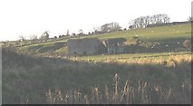
SH4573 : Lime kiln at Lledwigan
by Eric Jones
|
|
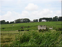
SH4573 : The disused limestone quarry below Lledwigan Farm
by Eric Jones
|
|
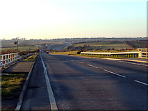
SH4573 : A5 road looking towards the Llangefni interchange
A5 road looking towards the Llangefni interchange, this section of the A5 road runs parallel to the dual carriageway across the Malltraeth Marsh
|
|
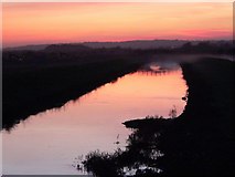
SH4572 : Sunset over Bont Buckley, Afon Cefni.
Cors Ddyga or Malltraeth Marsh was successfully reclaimed from the tide washed salt marsh in the 1820's. Pont Buckley (visible in reflection) was one of the "new bridges" that replaced the earlier Ferry Crossings. The Afon... (more)
|
|