Grid reference SH4175
near to Heneglwys, Isle of Anglesey/Sir Ynys Mon, Wales
Coverage
We have
48 images
in grid square SH4175
Contribute
Explore gridsquare SH4175
Surrounding area
Maps
 Map © Crown Copyright")
TIP: Click the map for more Large scale mapping
Tip: Click the map to open the coverage map
Sample images
Breakdown list
mentioning SH4175 [1]
A sample of 12 photos from 48
for SH4175
- View this square in the Browser >>>

|
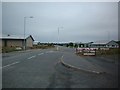
Mona Industrial Park
The Park seems to have gone under several variants of its name, but the current signs (in blue) clearly state 'Industrial Park'.
|
|
Mona Industrial Estate
This image was taken at SH41790875504 looking roughly south through the industrial estate. This estate is tacked onto the side of Mona Airfield which is owned by the MOD and used for training purposes.
|
|
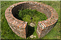
North Wales WWII defences: RAF Mona, Anglesey - LAA Emplacement & Blast Shelter (4)
by Mike Searle
-
LAA Emplacement: DoB ID: e42025
Blast Shelter: DoB ID: e11033
The gun pit is situated just a few yards east of an open blast shelter, the latter being the sole survivor of 14 that once stood at various locations in and around the... (more)
|

|
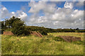
Grazing near RAF Mona
by JThomas
|

|
Old Milestone by the A5, Mona Airfield
Telford Plate by the A5, in parish of Bodfordd (Anglesey District), RAF Mona.
Inscription reads:-
HOLY-
HEAD
12
MONA
1
BANGOR
13
Surveyed
Milestone Society National ID: ANG_HH12
|

|
A Hawk approaches the southern end of the main runway at RAF Mona
by Eric Jones
|
|
|
Mona Airfield Panorama
by Clint Mann
Viewed from A5.
|
|
|
RAF Mona
by Eric Jones
Mona began life as what, by the end of WWI, was called RAF Llangefni. It was a base for non-rigid airships which, with Baldonell near Dublin, was responsible for anti-submarine patrols in the Irish Sea. In 1942, the old base became a... (more)
|

|
Unit Seven
by J Scott
Commercial unit occupied by SP Energy Networks on the Mona Enterprise Park.
|
|
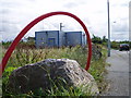
In The Loop
by J Scott
Primary electricity substation designed to look like a commercial unit on the Mona Enterprise Park.
|
|
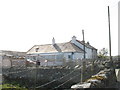
Druid Farmhouse, Mona
by Eric Jones
|
|
North Wales WWII defences: RAF Mona, Anglesey - LAA Emplacement (2)
by Mike Searle
-
LAA Emplacement: DoB ID: e42025
An elevated view of the gun pit. In the centre is a 'Motley stalk' machine gun mounting.
SH4175 : North Wales WWII defences: RAF Mona, Anglesey - LAA Emplacement (3)
|
Explore more images in this square: | View Filtering options | View all 48 images page by page >>> |
|