2008

SH4175 : RAF Mona

taken 16 years ago, near to Heneglwys, Isle of Anglesey/Sir Ynys Mon, Wales

This is 1 of 3 images, with title starting with RAF in this square
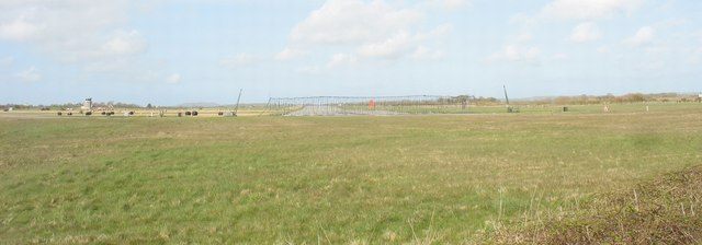
RAF Mona
RAF Mona
Mona began life as what, by the end of WWI, was called RAF Llangefni. It was a base for non-rigid airships which, with Baldonell near Dublin, was responsible for anti-submarine patrols in the Irish Sea. In 1942, the old base became a training centre, first for air gunners and then for air observers. In 1943 concrete runways were built over an area extending to some 3 square kilometres. In 1946 Mona was declared redundant, but in 1951 it became a relief landing ground for neighbouring RAF Valley. It is used by RAF during the weekdays and in the evenings and at the weekends, since 1974, by the Mona Flying Club.

LinkExternal link (Archive LinkExternal link )

Creative Commons Licence [Some Rights Reserved]   © Copyright Eric Jones and licensed for reuse under this Creative Commons Licence.
Category: Airfield
This photo is linked from: Automatic Clusters: · Runway at RAF Mona [5] · Mona Flying Club [4] ·
1:50,000 Modern Day Landranger(TM) Map © Crown Copyright
+
+
1:50,000 Modern Day Landranger(TM) Map © Crown Copyright
TIP: Click the map for more Large scale mapping
Grid Square
SH4175, 48 images   (more nearby 🔍)
Photographer
Eric Jones   (more nearby)
Date Taken
Wednesday, 23 April, 2008   (more nearby)
Submitted
Sunday, 27 April, 2008
Subject Location
OSGB36: geotagged! SH 413 756 [100m precision]
WGS84: 53:15.2282N 4:22.7830W
Camera Location
OSGB36: geotagged! SH 411 754
View Direction
Northeast (about 45 degrees)
Clickable map
+
NW N NE
W Go E
SW S SE
Image classification(about): Geograph
This page has been viewed about 72 times
You are not logged in login | register