Grid reference SH4174
near to Mona, Isle of Anglesey/Sir Ynys Mon, Wales
Coverage
We have
21 images
in grid square SH4174
Contribute
Explore gridsquare SH4174
Surrounding area
Maps
 Map © Crown Copyright")
TIP: Click the map for more Large scale mapping
Tip: Click the map to open the coverage map
Sample images
Breakdown list
images taken from SH4174 [1]
A sample of 12 photos from 21
for SH4174
- View this square in the Browser >>>
|
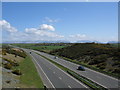
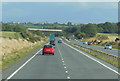
A55 Expressway
A view looking east along the A55 dual carriageway with the mountains of Snowdonia in the background.
|
|
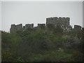
Bryn Twr folly castle
by Paul Brooker
A victorian folly castle
|
|
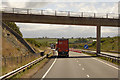
Minor Road Bridge over the North Wales Expressway
by David Dixon
|
|
A woodland caravan park at Tre-gof
by Eric Jones
|
|
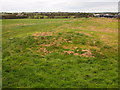
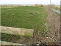
Tumulus Near Craiglas
A Bronze Age barrow.
|
|
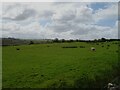
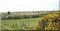
Sheep grazing, Graiglas
by JThomas
|
|
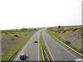
The A55 North Wales Expressway
by Ian S
Eastbound towards junction 6.
|
|
View west along the A55 at 17.00 hrs
by Eric Jones
This section of the A55 can not exactly be described as congested. Traffic problems on the A55 are much worse on the mainland.
|
|
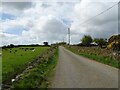
Minor road towards Graiglas
by JThomas
|
|
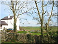
Roadside house near Bryn Twr
by Eric Jones
|
|
Poultry facility alongside the A55
by Eric Jones
|
|
A tumulus alongside the road to Mona
by Eric Jones
|
Explore more images in this square: | View Filtering options | View all 21 images page by page >>> |
|