Grid reference SH3976
near to Gwalchmai, Isle of Anglesey/Sir Ynys Mon, Wales
Coverage
We have
29 images
in grid square SH3976
Contribute
Explore gridsquare SH3976
Surrounding area
Maps
 Map © Crown Copyright")
TIP: Click the map for more Large scale mapping
Tip: Click the map to open the coverage map
Sample images
Breakdown list
A sample of 12 photos from 29
for SH3976
- View this square in the Browser >>>
|
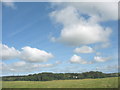
View NW across farmland in the direction of Coed Hendre Woodland
by Eric Jones
|
|
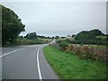
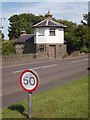
A5 Towards Gwalchmai
This image shows the A5 as it runs west towards Gwalchmai. It was taken from SH3948876165.
|
|
Holyhead 11
by Keith Evans
Milestone on the A.5 near to Gwalchmai, Isle of Anglesey for close up view see Link
|
|
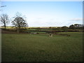
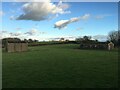
Farmland near Gwalchmai |
|
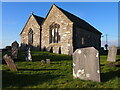
St Morhaiarn's Church, Gwalchmai |
|
Derelict buildings near Gwalchmai
by Steven Brown
|
|
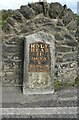
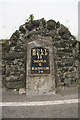
Old milestone beside Ffordd Caergybi (Holyhead Road)
by JThomas
Inscription reads:-
HOLY-HEAD 11
MONA 2
BANGOR 14
|
|
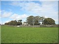
Castell Eden Farmhouse, Gwalchmai
by Eric Jones
This farm, and the neighbouring Bodwina, sepecialize in rearing Beltex sheep.
Link
|
|
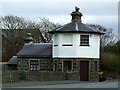
Old Tollhouse
Old tollhouse on the A5 outside Gwalchmai
|
|
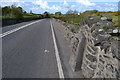
Old Milestone by the A5, Holyhead Road, Gwalchmai
Telford Plate by the A5, in parish of Trewalchmai (Anglesey District), Gwalchmai, partially set into wall.
Inscription reads:-
HOLY-
HEAD
11
MONA
2
BANGOR
14
Grade II listed by Cadw.
Reference Number: 20517... (more)
|
|
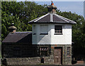
Toll House, Gwalchmai
On the A5, part of Telford's turnpike.
|
|
Gwalchmai Tollhouse
Gwalchmai Tollhouse,Trewalchmai,Isle of Anglesey,a Grade II listed building.
|
Explore more images in this square: | View Filtering options | View all 29 images page by page >>> |
|