Grid reference SH3870
near to Bethel, Isle of Anglesey/Sir Ynys Mon, Wales
Coverage
We have
just one image
mentioning SH3870 [Note: currently only matches 4 figure grid references]
Contribute
Explore gridsquare SH3870
Surrounding area
Maps
 Map © Crown Copyright")
TIP: Click the map for more Large scale mapping
Tip: Click the map to open the coverage map
We have
just one image
mentioning SH3870 [Note: currently only matches 4 figure grid references]
|
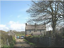
SH3871 : Tre-Ddafydd-isaf
by Eric Jones
The name of this farmhouse, south of the hamlet of Soar, means "lower (part of) David's homestead" Tre-Ddafydd-uchaf (=upper part of David's homestead) is in the adjoining square SH3870.
|
|