Grid reference SH3870
near to Bethel, Isle of Anglesey/Sir Ynys Mon, Wales
Coverage
We have
37 images
in grid square SH3870
Contribute
Explore gridsquare SH3870
Surrounding area
Maps
 Map © Crown Copyright")
TIP: Click the map for more Large scale mapping
Tip: Click the map to open the coverage map
A sample of 12 photos from 37
for SH3870
- View this square in the Browser >>>
|
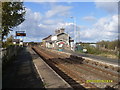
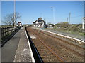
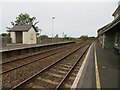
Bodorgan Station
by Peter Duddy
A remote railway station in the south of Anglesey serving a small hamlet with an interesting past. It is privately owned by the photographer.
|
|
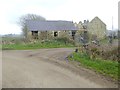
Old barn at Tre-Ddafydd-uchaf
by Oliver Dixon
|
|
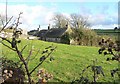
Cae'r Ddol, Bodorgan, Anglesey.
A view of a small traditional cottage called Cae'r Ddol. Not much has changed in this view in the past one hundred years.
|
|
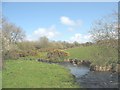
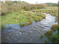
Afon Gwna near Melin Gwna
by Eric Jones
|
|
Bodorgan railway station, Anglesey
Opened in 1849 by the Chester & Holyhead Railway, later part of the London & North Western Railway.
View north west towards Ty Croes and Holyhead. It appears to have gained a waiting shelter on the Holyhead-bound platform and... (more)
|

|
New Class 142 'Pacer' DMU leaving Bodorgan for Llandudno, 1986
View eastward, towards Menai Bridge, Bangor etc.: ex-LNWR Chester - Holyhead main line. This wayside station in Anglesey has remained open for some reason, but the 'train' is a demoted 15.05 stopping service from Holyhead.
|
|
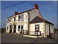
The Former Meyrick Hotel, Bodorgan |
|
Afon Gwna, Bodorgan |
|
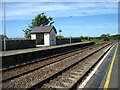
Bodorgan Station
One of several request stops on Anglesey (Ynys Môn). Inter-city trains will, of course, not stop but several local trains each day will stop if hailed from the platform.
Here we are looking towards Holyhead, not very far away.
|

|
Ordnance Survey Flush Bracket G4909
by Peter Wood
This bracket can be found on the wall of the former Merych Arms Hotel - now a private dwelling - at Bodorgan Station. The benchmark height is recorded as being 24.792 metres above sea level. For more detail see : Link
|
|
Bodorgan Station
Looking west towards Holyhead.
|
|
A diversion of water from Afon Gwna to Llyn Coron
by Eric Jones
This is a flood prevention scheme
|
Explore more images in this square: | View Filtering options | View all 37 images page by page >>> |
|