Grid reference NY7976
near to Stonehaugh, Northumberland, England
Coverage
We have
49 images
in grid square NY7976
Contribute
Explore gridsquare NY7976
Surrounding area
Maps
 Map © Crown Copyright")
TIP: Click the map for more Large scale mapping
Tip: Click the map to open the coverage map
Sample images
Breakdown list
A sample of 12 photos from 49
for NY7976
- View this square in the Browser >>>
|
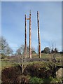
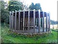
New totem poles in position
by Oliver Dixon
The celebrated totem poles of Stonehaugh were first fashioned by forestry workers in 1971 at a time when chainsaws were a novelty. After the base of the poles rotted, they were replaced in 1982 and again in 1992. In 2018, the poles were... (more)
|
|
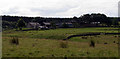
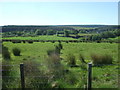
Roses Bower |
|
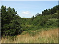
Valley of the Warks Burn
Warks Burn cuts dramtically through the landscape around Stonehaugh.
|
|
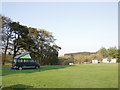
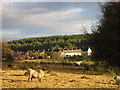
Camp site, Stonehaugh
Wind and solar powered. Excellent!
|
|
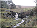
Waterfall on Middle Burn, Stonehaugh (set of 2 images)
by Les Hull
|
|
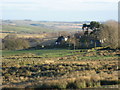
Stonehaugh and Warks Burn
Taken from the Sustrans Route 68 cycleway.
|
|
Stonehaugh, Wark Forest
by Les Hull
Keys to the Past Web Site: Stonehaugh village was built by the Forestry Commission in the 1950s and was designed by Dr Thomas Sharp. Some 113 houses were built, although the village was originally designed to be twice as big. The village... (more)
|
|
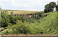
Warks Burn
Looking down Warks Burn at Standingstone Clints near Stonehaugh.
|
|
Stonehaugh Stargazing Pavilion
by Oliver Dixon
Opened in 2014, the Stargazing Pavilion provides a good spot from which to enjoy the landscape and the local wildlife. By night, the central room is an excellent place from which to observe the night sky, being sited within the... (more)
|
|
Sustrans Route 68 near Shiela Crag
Looking toward Cowcrook Moss and Brown Rigg. Old School House far right.
|
|
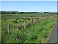
Rough pastures near Roses Bower
by Mike Quinn
|
|
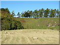
Biggy Haugh
by Mike Quinn
|
Explore more images in this square: | View Filtering options | View all 49 images page by page >>> |
|