Grid reference NY6588
near to Rushy Knowe [other Features], Northumberland, Great Britain
Coverage
We have
28 images
in grid square NY6588
Contribute
Explore gridsquare NY6588
Surrounding area
Maps
 Map © Crown Copyright")
TIP: Click the map for more Large scale mapping
Tip: Click the map to open the coverage map
Sample images
Breakdown list
images taken from NY6588 [3]
A sample of 12 photos from 28
for NY6588
- View this square in the Browser >>>
|
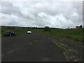
Gravel track, Mounces Viewpoint
by Steven Brown
|
|
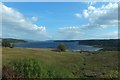
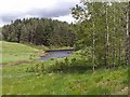
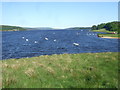
Kielder Water
by Barbara Carr
Looking along a stream bed, with Leaplish on the shore to the right.
|
|
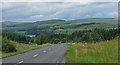
Country road, Kielder Forest (2)
Classed as a minor road, but to all intents and purposes a main road snaking through Kielder Forest.
Kielder Forest is the largest forest in England, and the largest man-made forest in Europe. It is owned and managed by the Forestry... (more)
|
|
Road to nowhere at Hawk Hirst
A road leads into Kielder Water - a remnant from a time prior to the inundation of the valley.
This photograph was taken during the Coronavirus (COVID-19) pandemic of 2020/21.
|
|
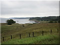
Hawk Hirst
by Oliver Dixon
A hidden inlet on Kielder Water, seen from the Lakeside Way.
|
|
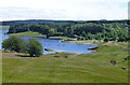
Kielder Water
Looking towards Leaplish Waterside Park.
|
|
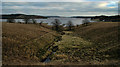
Mounces
by Richard Webb
Rough grazing above Mounces, a farm lost to the reservoir.
|
|
Leaplish
Sike above Leaplish on Kielder Water.
|

|
Hawkhirst Burn, Kielder
by Les Hull
|
|
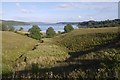
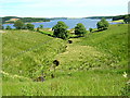
Rough pasture in Kielder Forest
by Russel Wills
With Kielder Water and Leaplish Waterside Park in the background.
|
|
Burn Leading to Kielder Water |
|
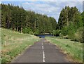
View from Lakeside Way over Kielder Water
Leaplish far right.
The Lakeside Way was recently completed (2009) and is a full perimeter walking and cycling route hugging the lakeside of the UK's largest body of water. (42 Km).
|
Explore more images in this square: | View Filtering options | View all 28 images page by page >>> |
|