Welcome to the Geograph Worldwide Homepage
Geograph is a concept and open source code for a online website to create a comprehensive collection of photographs capturing every part of given region.
Currently there are three active projects, shown below - including a photograph from each.
Geograph Britain and Ireland

Today's Photo of the day
TQ0386 : Chalfont House, Denham by Andrew CurtisShowroom and offices of Style Library, Zoffany and Sanderson.

Geograph Germany

Today's Photo of the day
UQC0136 : Landesstraße 148 - Bahnübergang by Schön-R
Das Foto zeigt einen Bahn³bergang der Landesstra▀e 148 in Richtung Kleinw³lknitz.
Geograph Channel Islands
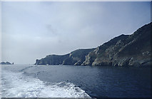
Random photo (doesn't have a daily photo)
WV4775 : Leaving the Maseline Harbour, Sark by John RostronTaken from the boat heading for Herm, this shows the Maseline harbour at the extreme left of the promontory. The tunnel from the harbour is also just visible. The small islets to the left are the Burons.
Geograph Britain and Ireland, also has a slightly simplified site schools.geograph.org.uk intended for use within Schools.
... and a sub-project just focusing on images in Ireland, www.geograph.ie.
Geograph Germany/Deutschland, also has a German/Deutsch language version at geo.hlipp.de.