Grid reference SO8217
near to Hempsted, Gloucestershire, England
Coverage
We have
235 images
in grid square SO8217
Contribute
Explore gridsquare SO8217
Surrounding area
Maps
 Map © Crown Copyright")
TIP: Click the map for more Large scale mapping
Tip: Click the map to open the coverage map
Sample images
Breakdown list
images taken from SO8217 [9]
A sample of 12 photos from 235
for SO8217
- View this square in the Browser >>>
|
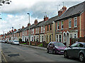
67-113 Seymour Road, Gloucester
Typical artisan housing of the last decades of the C19th.
|
|
On the A430, Hempsted Lane, heading south
by Rob Purvis
|
|
Timber yard alongside the Gloucester & Sharpness canal
Taken from the trip boat, Queen Boadicea II.
|
|
Mitchell's Mural
by Pebble
A mural on the side of a building belonging to Mitchell's, an air conditioning company.
|
|
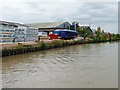
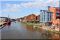
Gloucester Docks
Restored warehouse in the docks at Gloucester.
|
|
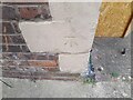
Ordnance Survey Cut Mark
by Adrian Dust
This OS cut mark can be found on No153 Southgate Street. It marks a point 13.945m above mean sea level.
|
|
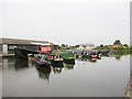
Gloucester, Monk Meadow Dock
by Alby
Monk Meadow Dock situated on the Gloucester & Sharpness canal southern from the proper docks.
|
|
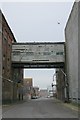
High Orchard
by Dave Bushell
Derelict buildings in Gloucester's dockland, looking north
|
|
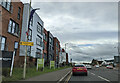
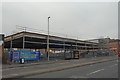
New Aldi in Gloucester
by John Winder
These things are springing up everywhere, now that no one's got any money and even relatively exalted worker ants like, say, night shift haulage company managers get paid a mere pittance. Here's a new Aldi under construction on... (more)
|
|
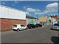
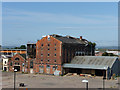
Disused warehouse, High Orchard
by Chris Gunns
|
|
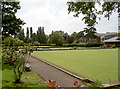
Spa Road greens
by Neil Owen
Home of the Gloucester Spa Bowling & Social Club. The greens date back to before the Second World War, and are beside what used to be the old spa and pump rooms.
|
|
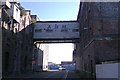
Derelict warehouse, Merchants' Road, Gloucester
The fairly new Gloucester Quays shopping mall is nearby. Although considerable progress in regenerating the docks area has been made several old warehouses remain to be redeveloped. In the meantime the buildings provide home for feral... (more)
|
Explore more images in this square: | View Filtering options | View all 235 images page by page >>> |
|