Grid reference SH3967
near to Bodorgan, Isle of Anglesey/Sir Ynys Mon, Wales
Coverage
We have
5 images
in grid square SH3967
Contribute
Explore gridsquare SH3967
Surrounding area
Maps
 Map © Crown Copyright")
TIP: Click the map for more Large scale mapping
Tip: Click the map to open the coverage map
We have
5 images
for SH3967
|
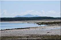
Malltraeth Sands & Afon Cefni
Newborough Forest is on the far side of the estuary and mountains of Snowdonia beyond.
|
|
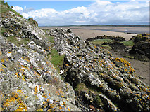
Sediments ancient and modern
Looking over an outcrop of the Gwna Melange, a metamorphosed sedimentary rock of Cambrian age to the contemporary sediments of the Malltraeth Sands. The Afon Cefni channel can be seen in the middle distance, at approximately low tide. The... (more)
|
|
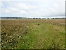
Malltraeth Sands
by Eirian Evans
A large area of saltmarsh and sands at the mouth of the Cefni estuary
|
|
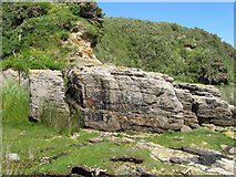
Conglomerate beds
Beds of a pebble conglomerate dip steadily to the right in this image. It is widely regarded as being a basal formation to the local Carboniferous outcrop, but here its position in the stratigraphy is rather obscure. Similar beds can be... (more)
|
|
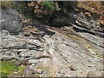
Outcrop of unconformity
At the left of this image rocks belonging to the Gwna Melange can be seen. These are of Pre-Cambrian age and significantly metamorphosed. Falling down and spreading over the ancient topography, a rough cliff-like feature, are much younger... (more)
|
|