Grid reference SH457733
near to Pentre Berw, Isle of Anglesey/Sir Ynys Mon, Wales
Coverage
We have
29 images
in grid square SH4573
Contribute
Explore centiquare SH457733
Explore gridsquare SH4573
Surrounding area
Maps
 Map © Crown Copyright")
TIP: Click the map for more Large scale mapping
Tip: Click the map to open the coverage map
Sample images
Breakdown list
images taken from SH4573 [1]
A sample of 12 photos from 29
for SH4573
- View this square in the Browser >>>
|
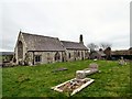
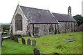
St Cristiolus's Church, Llangristiolus
Reputedly founded by St Cristiolus in 610, the present building dates from the 12th and 13th centuries. Alterations were made in the 16th century, when the large east window in Perpendicular style was added to the chancel. In 1852,... (more)
|
|
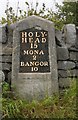
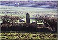
Milestone
by Keith Evans
Milestone on the A.5 near to Llangristiolus, Isle of Anglesey for overall view see Link
|
|
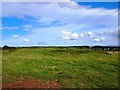
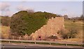
Mynwent y Llwyn
Also known as Llwyn Tegai. Its difficult to see, but it is a low (artificial) mound, that some traditions associate with a small chapel. Pentre Berw is in the distance.
|
|
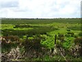
Reclaimed farmland on the western edge of the Malltraeth Marsh
by Eric Jones
|
|
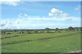
Rough grazing near Pont Bulkeley
by JThomas
|
|
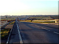
A5 road looking towards the Llangefni interchange
A5 road looking towards the Llangefni interchange, this section of the A5 road runs parallel to the dual carriageway across the Malltraeth Marsh
|
|
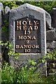
Old Milestone by the A5, Holyhead Road, Llangristiolus Parish
Telford Plate by the A5, in parish of Llangristiolus (Anglesey District), South of Creigle, North side of road, below the church of St Cristiolus.
Inscription reads:-
HOLY-
HEAD
15
MONA
2
BANGOR
10
Grade II listed.
Reference... (more)
|
|
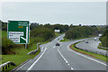
North Wales Expressway, Westbound Exit at Junction 6
by David Dixon
|
|
Eglwys St. Cristiolus - Llangristiolus Parish Church
Reputedly founded by St. Cristiolus in 610, the present building dates from the 12th and 13th centuries.
|
|
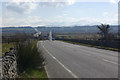
A5 towards Gaerwen
The A5 and the A55 run in parallel across Anglesey; the older A5 passes through several villages, whereas the new A55 is a fast dual carriageway forming a through route from Chester to Holyhead. In this view the snow-covered peaks of... (more)
|
|
A Disused Lime Kiln near Lledwigan, Llangefni.
A view of a disused lime kiln along side the A55 near Lledwigan, Llangefni.
|
|
Lledwigan Standing Stone
by Ray West
A Bronze Age Standing Stone, with the 20th Century A55 in the background.
|
Explore more images in this square: | View Filtering options | View all 29 images page by page >>> |
|