Grid reference SH406757
near to Heneglwys, Isle of Anglesey/Sir Ynys Mon, Wales
Coverage
We have
37 images
in grid square SH4075
Contribute
Explore centiquare SH406757
Explore gridsquare SH4075
Surrounding area
Maps
 Map © Crown Copyright")
TIP: Click the map for more Large scale mapping
Tip: Click the map to open the coverage map
Sample images
Breakdown list
A sample of 12 photos from 37
for SH4075
- View this square in the Browser >>>
|
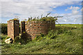
North Wales WWII defences: RAF Mona, Anglesey - LAA Emplacement (6)
by Mike Searle
-
LAA Emplacement: DoB ID: e42026
On the western periphery of the airfield is the second of two surviving LAA emplacements.
SH4075 : North Wales WWII defences: RAF Mona, Anglesey - LAA Emplacement (7)
|
|
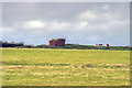
Anglesey Showground
Buildings at Anglesey Showground, The showground hosts the Anglesey County Show every year, as well as numerous other events
|
|
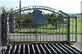
Gate to Mona Flying Club, RAF Mona
by Eric Jones
|
|
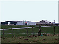
Maes Awyr Mona Airfield
by Alan Fryer
Mona is used as a relief landing strip by aircraft from RAF Valley nearby, as well as by Mona Flying Club Link
|
|
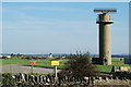
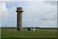
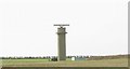
Radar Tower, RAF Mona
by JThomas
|
|
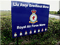
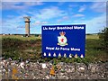
Llu Awyr Brenhinol Mona
Entrance sign at RAF Mona
|
![SH4075 : Anglesey Agricultural Show 2008 [5] by Robin Drayton](https://s3.geograph.org.uk/photos/92/33/923307_a3e48cad_120x120.jpg)
|
Anglesey Agricultural Show 2008 [5]
Sheep shearing team contest.
|
|
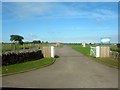
Mynedfa Safle Sioe Môn - Anglesey Showground Entrance
by Alan Fryer
The cattle grid and gates at the entrance to the showground.
|
|
North Wales WWII defences: RAF Mona, Anglesey - LAA Emplacement (8)
by Mike Searle
-
LAA Emplacement: DoB ID: e42026
RAF Mona is an active airfield, and permission must be sought in order to visit. With thanks to Squadron Leader Dave Williams of RAF Valley for arranging access.
BACK:- SH4175 : North Wales WWII defences: RAF Mona, Anglesey - LAA Emplacement (1)
|
|
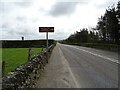
Ffordd Caergybi (Holyhead Road)
by JThomas
|
|
Royal Air Force Mona
The site is mainly used as a relief landing ground for RAF Valley.
|
|
Radar Tower at RAF Mona
by Eric Jones
Mona is equipped with a Cossor Secondary Surveillance Radar system operated by RAF Valley Air Traffic Control. Currently, between them, mother and daughter stations handle some 65,000 take-offs and landings p.a. This makes Valley the... (more)
|
Explore more images in this square: | View Filtering options | View all 37 images page by page >>> |
|