Grid reference NT1783
near to Dalgety Bay, Fife, Scotland
Coverage
We have
36 images
in grid square NT1783
Contribute
Explore gridsquare NT1783
Surrounding area
Maps
 Map © Crown Copyright")
TIP: Click the map for more Large scale mapping
Tip: Click the map to open the coverage map
Sample images
Breakdown list
images taken from NT1783 [2]
A sample of 12 photos from 36
for NT1783
- View this square in the Browser >>>
|
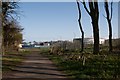
Eastern end of Oil Terminal at Dalgety Bay |
|
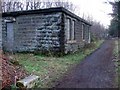
Braefoot Plantation wartime fortifications
Disused with windows bricked up but in perfect condition this building was there to service the artillery gun emplacements at Braefoot. Woodland path running alongside which leads to Braefoot Point.
|
|
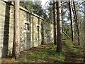
Military buildings, Braefoot Plantation
by Richard Webb
As a headland in the Firth of Forth, Braefoot was fortified in World War 1.
|
|
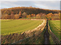
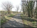
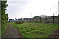
Link Path
by Rob Burke
Eight years on, and NT1783 : Link Path does not seem to have changed at all. This path provides access to the woodland at Braefoot from the Fife Coastal Path.
|
|
Private road to Braefoot Point
by Oliver Dixon
The road carries the status of public right of way.
|
|
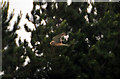
The Kestrel (Falco tinnunculus)
by Robin Clark
Although the Kestrel is a common bird of prey its still hard to pass on taking its photograph.
|
|
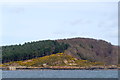
Braefoot Point from the sea
Taken from the Maid of the Forth en route to Inchcolm.
|
|
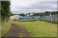
Braefoot Bay Marine Terminal
by Graeme Yuill
The terminal is used to export liquefied petroleum gas which is produced at Mossmorran near Cowdenbeath.
|
|
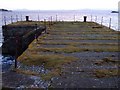
Braefoot Point
Disused Second World War stone pier. The Haystack on the right and Inchcolm on the left. Edinburgh skyline on the far coast.
|
|
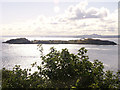
Braefoot Bay & Mortimer's Deep
Treetops at the cliff edge. Taken from Braefoot Plantation looking SE toward Inchcolm Island across Mortimer's Deep and to Edinburgh. Inchmickery Insland and Arthur's Seat visible behind Inchcolm. There are some good walks... (more)
|
|
Braefoot Terminal
North Sea oil and gas is processed at Mossmorran and piped here to be loaded onto ships for export.
|
|
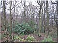
Woodland, Dalgety Bay
by Richard Webb
The dreaded Rhododendron ponticum lurking in woodland above Dalgety Bay.
|
Explore more images in this square: | View Filtering options | View all 36 images page by page >>> |
|