SP6890 : Gumley from the churchyard
taken 25 days ago, near to Gumley, Leicestershire, England
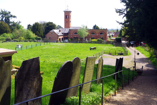
Gumley from the churchyard
Gumley seems an insignificant place now but this small south Leicestershire village has an intriguing history that goes back to the 8th century kings of Mercia. It is known that Æthelbald held a synod here in 749 that was significant in determining the public obligations of the church and Offa came here in 772 and 779 for the 'witenagemot', meetings of the King's council. In later times Gumley Hall came to be the most significant building in the area. It was built in 1764 for Joseph Cradock, a Leicester hosier and patron of the arts who moved in London literary society. He built a theatre here that was used by David Garrick and visitors were also attracted to take the mineral waters provided by a chalybeate (iron salts) spring found in 1789. Subsequent owners and tenants were interested in foxhunting and the sizeable stable block with its water tower, built in 1870, can be seen in this view. In the Second World War the hall was used for training resistance fighters and members of the Special Operations Executive but it was demolished in the 1960s; it stood to the left of this shot.
 Map © Crown Copyright")
TIP: Click the map for more Large scale mapping
- Grid Square
- SP6890, 21 images (more nearby 🔍)
- Photographer
- Stephen McKay (more nearby)
- Date Taken
- Wednesday, 8 May, 2024 (more nearby)
- Submitted
- Monday, 13 May, 2024
- Subject Location
-
OSGB36:
 SP 6805 9013 [10m precision]
WGS84: 52:30.2898N 0:59.9326W - Camera Location
-
OSGB36: SP 6798 9019
- View Direction
- Southeast (about 135 degrees)