2015
SH5471 : Pont Britannia
taken 9 years ago, near to Llanfair Pwllgwyngyll, Isle of Anglesey/Sir Ynys Mon, Wales
This is 1 of 30 images, with title Pont Britannia in this square
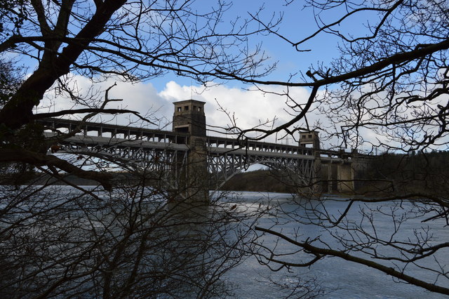
Pont Britannia
Opened on 5 March 1850, the original Britannia Bridge (Pont Britannia in Welsh) was designed by Robert Stephenson as a railway bridge, consisting of parallel wrought iron tubes supported by the stone towers.
On 23 May 1970, a fire broke out in the tube at the mainland end, spreading across the whole bridge and making the tubes unsafe. It was subsequently rebuilt in its current form, as a two-decked arched bridge, retaining the original piers. The lower deck, carrying the railway (now single track), was opened on 30 January 1972, although the upper deck, carrying a wide single carriageway A55, did not open until 1980.
Grade II listed (and retaining the status, despite the rebuilding, because of the bridge piers) - see Link .
.
See other images of Pont Britannia
On 23 May 1970, a fire broke out in the tube at the mainland end, spreading across the whole bridge and making the tubes unsafe. It was subsequently rebuilt in its current form, as a two-decked arched bridge, retaining the original piers. The lower deck, carrying the railway (now single track), was opened on 30 January 1972, although the upper deck, carrying a wide single carriageway A55, did not open until 1980.
Grade II listed (and retaining the status, despite the rebuilding, because of the bridge piers) - see Link
See other images of Pont Britannia
 Map © Crown Copyright")
TIP: Click the map for more Large scale mapping
- Grid Square
- SH5471, 279 images (more nearby 🔍)
- Photographer
- N Chadwick (more nearby)
- Date Taken
- Saturday, 21 February, 2015 (more nearby)
- Submitted
- Wednesday, 13 May, 2015
- Subject Location
-
OSGB36:
 SH 5413 7101 [10m precision]
WGS84: 53:12.9640N 4:11.1628W - Camera Location
-
OSGB36: SH 5453 7101
- View Direction
- WEST (about 270 degrees)