Grid reference TF1688
near to North Willingham, Lincolnshire, England
Coverage
We have
36 images
in grid square TF1688
Contribute
Explore gridsquare TF1688
Surrounding area
Maps
 Map © Crown Copyright")
TIP: Click the map for more Large scale mapping
Tip: Click the map to open the coverage map
Sample images
Breakdown list
images taken from TF1688 [2]
A sample of 12 photos from 36
for TF1688
- View this square in the Browser >>>
|
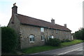
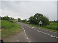
Cottages by the Main Road
by Chris
|
|
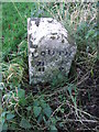
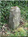
Old Milepost
by Keith Evans
Old milepost on the A631 near to North Willingham, Lincolnshire. For overall view see Link
Grade II Listed. List Entry Number: 1166262... (more)
|
|
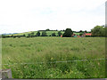
Looking towards The Clump
by David Wright
Picture taken from the verge of the A631 near North Willingham church looking North towards the small wooded hill called The Clump.
|
|
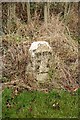
Turnpike Milestone
Milestone at North Willingham showing 3 miles and 6 furlongs to Rasen, the other side says Louth 11m 0f, installed after the road was turnpiked in 1765
|

|
Access road to Ash Farm |
|
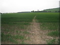
Footpath to Tealby
The route is clear through this field of wheat.
|
|
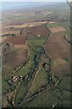
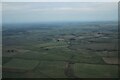
Willingham Hill to Ludford: aerial 2017
by Chris
|
|
Old milepost on the A631 near to North Willingham, Lincolnshire
by Hilary Jones
Carved stone post by the A631, in parish of North Willingham (West Lindsey District), Willingham Road, on the verge, on South side of road. Rasen detail stone, erected by the Dexthorpe turnpike trust in the 19th century. For overall view... (more)
|
|
A631 to Ludford
by John Firth
From Ash Farm entrance
|
|
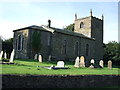
Church of St. Thomas, North Willingham
by JThomas
|
|
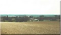
Settlement remains, North Willingham: aerial 2023 (1)
by Chris
See: Link
|
|
North Willingham in 1984
by John Baker
View taken from Six Hills Road
|
Explore more images in this square: | View Filtering options | View all 36 images page by page >>> |
|