Grid reference SY3892
near to Morcombelake, Dorset, England
Coverage
We have
65 images
in grid square SY3892
Contribute
Explore gridsquare SY3892
Surrounding area
Maps
 Map © Crown Copyright")
TIP: Click the map for more Large scale mapping
Tip: Click the map to open the coverage map
Sample images
Breakdown list
taken pre 2000 [1]
A sample of 12 photos from 65
for SY3892
- View this square in the Browser >>>
|
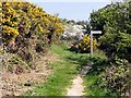
Footpath Junction with Gorse
by Tony Atkin
Straight on for a footpath inland or turn right to follow the coast path.
|
|
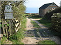
Westhay Farm
Cattle grid at the entrance to Westhay Farm.
|
|
Footbridge over Westhay Water
Golden Cap in the background.
|
|
Westhay Water
Westhay Water coming off the cliff
|
|
Westhay Farm from the coastal path
by N Chadwick
|
|
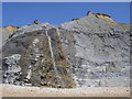
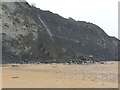
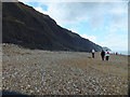
Rock fall at Charmouth beach, good for fossil hunters
by Rob Purvis
|
|
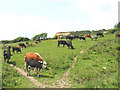
Cattle grazing at Westhay Farm |
|
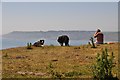
West Dorset : Coastal Scenery
by Lewis Clarke
A man and his dogs sitting in the sunshine overlooking the Dorset coastline.
|
|
The Beach at Charmouth,Dorset
Searching for Fossils
|
|
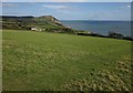
Field at Westhay Farm
by Derek Harper
From the coast path and the Monarch's Way following W16/91. Westhay Farm is on the left, with Golden Cap beyond. The Isle of Portland can be seen on the horizon.
|
|
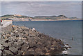
Dorset Coast
by MDS
View across Lyme Regis new protection Cobb towards Golden Cap
|
|
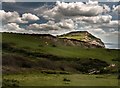
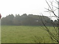
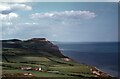
The Dorset coast east of Charmouth
In the foreground is Westhay Farm. Conspicuous beyond the farm is the flat-topped Golden Cap, at 191m the highest point on the south coast of England. Though a few argue that as the cliff is not vertical, the summit is about 250m inland... (more)
|
Explore more images in this square: | View Filtering options | View all 65 images page by page >>> |
|