Grid reference SX7037
near to Bolberry, Devon, England
Coverage
We have
43 images
in grid square SX7037
Contribute
Explore gridsquare SX7037
Surrounding area
Maps
 Map © Crown Copyright")
TIP: Click the map for more Large scale mapping
Tip: Click the map to open the coverage map
Sample images
Breakdown list
images taken from SX7037 [1]
A sample of 12 photos from 43
for SX7037
- View this square in the Browser >>>
|
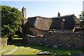
The Olde Cottage
by Bill Boaden
A thatched cottage at Lower Soar. The footpath from the coast comes down the side of this cottage.
|
|
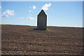
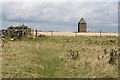
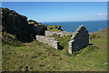
West Soar Admiralty Signal Station
by jeff collins
Built in 1794. A rare survivor of a chain of signal stations that used to run the length of the Channel coast. All that remains now is this tower which has recently been restored. From the path to Higher and Lower Soar.
|
|
Soar Mill Cove Hotel and valley
by David Smith
|
|
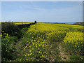
Oilseed rape |
|
Gorse in bloom by the coastal path looking west towards Soar Mill Cove
by Bob Cantwell
|
|
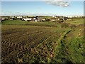
Footpath to Lower Soar
by Tony Atkin
This footpath runs inland from the coast, across the fields to Lower Soar Farm. I would like to tell you what that building is for but I don't know. I can only say that it is a tall square shaped building with a pyramidal roof which... (more)
|
|
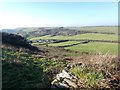
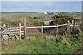
Footpath to Soar
Footpath and stile with Soar in the background.
|
|
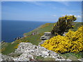
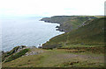
Malborough: towards The Warren
Looking east-south-east on a coast path not the South West Coast Path, which runs inland here on part of the National Trust estate
|
![SX7037 : A coastal walk around Bolt Head and The Warren [52] by Michael Dibb](https://s1.geograph.org.uk/geophotos/07/60/44/7604457_d0454d5f_120x120.jpg)
|
A coastal walk around Bolt Head and The Warren [52]
by Michael Dibb
Seen from the path is the former Admiralty Signal Station. A small square building, constructed in 1794 of Slatestone rubble stone with a pyramidal stone corbelled roof. See SX7037 : A coastal walk around Bolt Head and The Warren [50] and SX7037 : A coastal walk around Bolt Head and The Warren [51]. The station is listed, grade II, with... (more)
|
|
Soar
by Derek Harper
The hamlet of two farms and associated buildings is now dominated by holiday accommodation, principally the lodges at Salcombe Retreat. Note how the older buildings are set below the skyline, in this view from Malborough Footpath 15 at... (more)
|
|
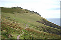
Malborough: near Steeple Cove
Looking north west along coastline which is all part of the National Trusts portfolio to Bolberry Down
|
|
Warren Barn (remains of )
by jeff collins
Hidden from view from the main path.
|
Explore more images in this square: | View Filtering options | View all 43 images page by page >>> |
|