Grid reference ST6968
near to North Stoke, Bath And North East Somerset, England
Coverage
We have
48 images
in grid square ST6968
Contribute
Explore gridsquare ST6968
Surrounding area
Maps
 Map © Crown Copyright")
TIP: Click the map for more Large scale mapping
Tip: Click the map to open the coverage map
Sample images
Breakdown list
taken pre 2000 [1]
A sample of 12 photos from 48
for ST6968
- View this square in the Browser >>>
|
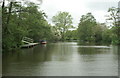
River Avon above Swineford
by Pierre Terre
|
|
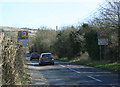
2010 : A431 Thank you for driving carefully
They really mean it.
Leaving Swineford heading south east for Kelston and Bath.
The hill in the distance to the left rises to Kelston Round Hill.
|
|
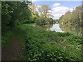
Kennet & Avon Canal Walk
Kennet & Avon Canal Walk heading by Saltford Mead alongside the River Avon
|
|
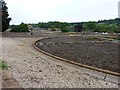
Saltford Sewage Works
by Rick Crowley
According to Wessex Water
"The address for Saltford STW is Mead Lane, Saltford, BS31 3ER. This sewage works is the main treatment works serving Bath and lies in a scenic location close to the River Avon."
|
|
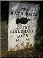
Old Boundary Marker by the A431, Bath Road, Kelston Parish
Turnpike Terminus Marker by the A431, in parish of Kelston (Bath And North East Somerset District), Bath Road, North of Kelston, near Depot gates, fixed to large stone in wall, beside road. Also recorded as milepost SO_BRBA07A... (more)
|
|
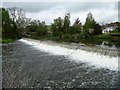
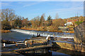
Swineford weir, River Avon
With a normal fall of about 1.3 metres.
|
|
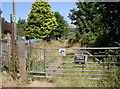
The end of Mead Lane
by Neil Owen
And the beginning of a footpath to the River Avon, which takes you to the old riverside railway station. Travellers can use either the small or large section of the gate. Oh, and no sneaky fishing!
|
|
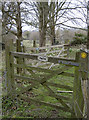
Path, no path
by Neil Owen
Some helpful signs on the various gates as they converge here.
|
|
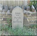
Commemorative Marker on the A431 Bath Road at Swineford
Commemorative Marker against a stone garden wall on the southwest side of the A431 Bath Road at Swineford, opposite a former chapel. On the boundary of Bitton and North Stoke parishes, South Gloucestershire and Bath and North East Somerset.... (more)
|
|
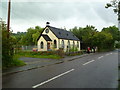
Swineford, tin church
by Mike Faherty
Former Congregational church, now Prospect Primary School: Link
|
|
Swineford Weir
Weir at Swineford, Somerset.
|
|
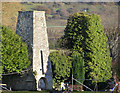
Old Annealing Furnaces Kelston
by Rick Crowley
This was taken from the other side of the River Avon by the Jolly Sailor Pub in Saltford
|
Explore more images in this square: | View Filtering options | View all 48 images page by page >>> |
|