Grid reference ST3062
3 km from Kewstoke, North Somerset, England
Coverage
We have
242 images
in grid square ST3062
Contribute
Explore gridsquare ST3062
Surrounding area
Maps
 Map © Crown Copyright")
TIP: Click the map for more Large scale mapping
Tip: Click the map to open the coverage map
A sample of 12 photos from 242
for ST3062
- View this square in the Browser >>>
|
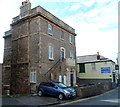
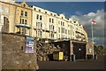
Upper Kewstoke Road, Weston-Super-Mare
At the junction of Camp Road North.
|
|
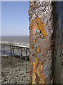
On land or sea, the iron is reclaimed
by Neil Owen
Some of the railings at the (barricaded) pier tollhouse, matching the familiar brown appearance that can also be seen on the pier itself.
|
|
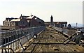
Pier to Birnbeck Island |
|
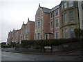
Weston Mansions, Weston-super-Mare
by Jaggery
Viewed across Birnbeck Road. The 3-storey house has been converted to flats.
Steps lead up to a first-floor front door with two letterboxes.
The Captain's Cabin Link is on the right.
|
|
Claremont Crescent, Weston-Super-Mare
by Derek Harper
The crescent is listed and described at Link
|
|
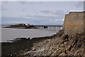
Weston-Super-Mare : Coastline & Birnbeck Island
by Lewis Clarke
Looking towards Birnbeck Island from a path heading along the coast.
|
|
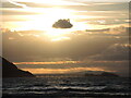
A silver lining over Birnbeck Island?
by Neil Owen
The Grade II* listed pier is the only one to reach an island in Britain. It opened in 1867 and in later times was a secret weapon testing site in WWII, a photoshoot for a young Beatles group and an R.N.L.I. station. However, the pier... (more)
|

|
View to Birnbeck Pier and Island from Knightstone Island in Weston-super-Mare
The future of this island seems unclear. Wikipedia article here Link
|
|
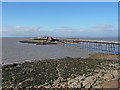
Weston-Super-Mare - Birnbeck Pier
by Chris Talbot
Birnbeck Pier is a pier is situated on the Bristol Channel approximately 18 miles south west of Bristol. It links the mainland with Birnbeck Island, a 1.2 hectares rocky island just to the west of Worlebury Hill, and is the only pier in... (more)
|
|
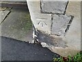
Ordnance Survey Cut Mark
by Adrian Dust
This OS cut mark can be found on Penwartha Lodge, Camp Road. It marks a point 29.057m above mean sea level.
|
|
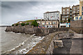
Anchor Head, Weston-super-Mare
View north towards Anchor Head.
|
|
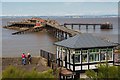
Birnbeck Pier
by Oliver Mills
A very postcardly scene, despite it being one which currently presents great ruination. The tollhouse in the foreground has been refurbished, being used as a visitor centre and shop by the pier charity. At the time of photographing, a... (more)
|
Explore more images in this square: | View Filtering options | View all 242 images page by page >>> |
|