Grid reference SO9006
near to Bisley, Gloucestershire, England
Coverage
We have
64 images
in grid square SO9006
Contribute
Explore gridsquare SO9006
Surrounding area
Maps
 Map © Crown Copyright")
TIP: Click the map for more Large scale mapping
Tip: Click the map to open the coverage map
Sample images
Breakdown list
A sample of 12 photos from 64
for SO9006
- View this square in the Browser >>>
|
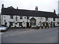
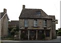
The Stirrup Cup public house, Bisley
Village pub.
|
|
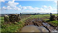
Young cereal field near Bisley
Typical Cotswold view in late winter.
|
|
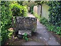
Stone Stile, Bisley
by Jayne Tovey
On Gloucestershire footpath MBL148 between two arms of Windyridge. the alternative view looking back is SO9006 : Stone Stile, Bisley.
|
|
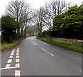
Calf Way north of Bisley
by Jaggery
North of the junction on the left, Cheltenham Road behind the camera becomes Calf Way ahead.
Pointing ahead, a sign near the camera shows two miles to The Camp, five miles to Birdlip.
|
|
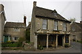
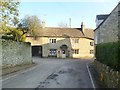
The Bear Inn, Bisley
The Bear Inn in Bisley used to be the court house, the columns date from the early 17th century.
|
|
Stone Stile off Van Der Breen St., Bisley GS1039
by Ian Roberts
Stone Slab Stile off road (Bisley to Water Lane) behind saltbin, Bisley. Stile is set-aside, now a kissing gate. MBL116 Leads off field behind Rectory Farm on Van Der Breen Street
|
|
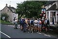
SRC Jubilee Walk 1953 - 2003 - Bisley, Gloucestershire
The year 2003 saw the 50th anniversary of the Stroud Rambling Club. This Club had sections for walkers, cyclists, climbers, cavers, canoeists and horse riders. Celebrations took place over the weekend of the 19th and 20th July. The Saturday... (more)
|
|
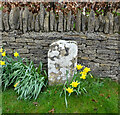
"Stone", Bisley Rd, Bisley
by Mr Red
In front of the boundary wall to modern houses. At ½ mile from Bisley on the ancient route from Cirencester to Gloucester, this might have served as a way marker at some stage. It is mid point 'twixt... (more)
|
|
The Bear Inn, Bisley
by Rob Farrow
A wonderful Cotswold stone pub in the village of Bisley with an unusual pillared façade.
|
|
George Street house, Bisley
by Jaggery
Opposite the Bear Inn. Link
|
|
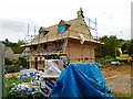
New house, Bisley |
|
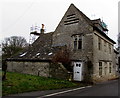
Bisley, village stores
by Mike Faherty
On High Street; formerly also post office. C18; listed by English Heritage: Link
|
Explore more images in this square: | View Filtering options | View all 64 images page by page >>> |
|