Grid reference SN8342
4 km NE of Cynghordy, Carmarthenshire/Sir Gaerfyrddin, Wales
Coverage
We have
29 images
in grid square SN8342
Contribute
Explore gridsquare SN8342
Surrounding area
Maps
 Map © Crown Copyright")
TIP: Click the map for more Large scale mapping
Tip: Click the map to open the coverage map
Sample images
Breakdown list
images taken from SN8342 [2]
A sample of 12 photos from 29
for SN8342
- View this square in the Browser >>>
|
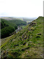
On The Sugar Loaf
Pic Nic area off the A483 in shot from the top of The Sugar Loaf
|
|
Hairpin bend on the A483 road from the Sugar Loaf hill
Great fun to drive, this stretch of road can be easily viewed from the summit above.
|
|
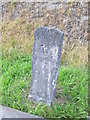
Mile Stone, Llandovery 7
by Adrian Dust
On the road at Sugar Loaf.
|
|
Sugar Loaf summit
by Flying Stag
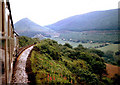
This striking hilltop marks the summit of the main A483 road which leads from Builth Wells (Llanfair-ym-Muallt) south-west into Carmarthenshire (Sir Gaerfyrddin). The Heart of Wales railway line runs through a tunnel just below the summit.
|
|
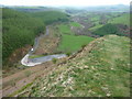
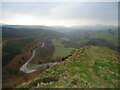
Sugar loaf mountain, Wales
We are on top of the hill looking down south towards Llandovery.
|
|
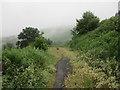
Forest track by the Sugar Loaf
The view lost in the mist.
|
|
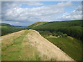
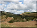
The view from Sugar Loaf
Sugar Loaf is a conspicuous lump in the valley between Llanwrtyd Wells and Llandovery: here we are looking south-west towards the latter. The A483 connects these two towns and has to follow three sides of a rectangle to pass it: one of... (more)
|
|
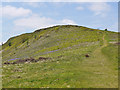
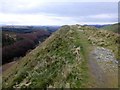
Path up the Sugar Loaf
by Nigel Brown
A public footpath, easily accessed from the car park.
|
|
Sugar Loaf
by Rude Health
Looking down to A483 road heading west as seen from the summit of Sugar Loaf, 323 metres and a P32 hill.
|
|
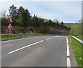
Warning signs alongside the A483 near Sugar Loaf
by Jaggery
Possibility of falling rocks ahead and the certainty of a bend in the road. Reduce speed now.
|
|
View from the Sugar Loaf, near Llandovery
by John Dalling
A landscape view from the Sugar Loaf, near Llandovery, on a bright sunny afternoon.
|
|
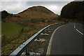
Sugar Loaf
The A483 between Llandovery and Builth Wells contours around Sugar Loaf.
|
Explore more images in this square: | View Filtering options | View all 29 images page by page >>> |
|