Grid reference SJ9594
near to Gee Cross, Tameside, England
Coverage
We have
1,869 images
in grid square SJ9594
Contribute
Explore gridsquare SJ9594
Surrounding area
Maps
 Map © Crown Copyright")
TIP: Click the map for more Large scale mapping
Tip: Click the map to open the coverage map
A sample of 12 photos from 1,869
for SJ9594
- View this square in the Browser >>>
|
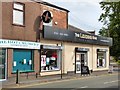
The Leading Edge
Hair and Beauty salon next door to the Hot Crumpet sandwich shop on Dowson Road.
|
|
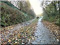
Trans Pennine Trail
The Trans Pennine Trail and National Cycle Route 62 on the trackbed of the former Godley Junction to Apethorn railway. The left hand side is for horse riders and the right hand side for walkers and cyclists.
|
|
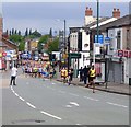
Dr Ron Hyde 7 Mile Race 2018 (2)
The front runners on Market Street with eventual winner Mohammed Aburezeq leading from the start.
|
|
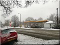
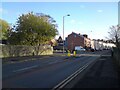
Dowson Road in the snow
Snow had started falling in the middle of the night. The main roads had not been gritted and traffic conditions were chaotic. By lunchtime traffic on the A627 Dowson Road past the Shell Filling Station was moving but the snow was still falling.
|
|
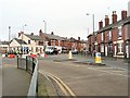
Stockport Road
The B6468. The signpost at the end of Peel Street still reads Hyde Hospital even though there hasn't been a hospital there for decades and the whole site is now populated by housing.
|
|
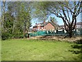
Dandelions at Swains Valley
The dandelions (as well as some daises) are now flowering at Swains Valley. In the background is the bottom end of Markland Street.
|
|
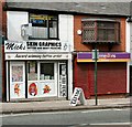
Skin Graphics
Mike's tattoo and body piercing studio on Market Street.
|
|
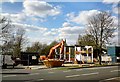
Work on Shell Filling Station
The Shell filling station on Dowson Road closed for 13 weeks in 2012 for a revamp. Here the canopy and fuel pumps have been removed and now the canopy supports are being demolished.
|
|
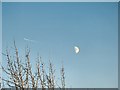
Over the tree tops
A plane emits contrails moving away from the waxing gibbous moon in the afternoon sky.
|
|
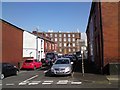
Bradbury Street
Until 2018 an industrial building occupied the space beyond the terraced houses on the right SJ9594 : Bradbury Street. It was connected two storeys up to the building on Dawson Street by a covered bridge. That has now been demolished to provide extra... (more)
|
|
Ring'o'Bells Roundabout
by Roger May
New roundabout at the top of Market Street, outside the Ring'o'Bells public house.
|
|
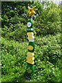
National Cycle Network Milepost
On the former Godley Junction to Woodley railway route. The sign has mileage to Apethorn and Godley. It is positioned east of the footbridge that now links the north and south parts of Grange Road.
|
Explore more images in this square: | View Filtering options | View upto 1000 images page by page >>> |
|