Grid reference SH7782
near to Llandudno, Conwy, Wales
Coverage
We have
528 images
in grid square SH7782
Contribute
Explore gridsquare SH7782
Surrounding area
Maps
 Map © Crown Copyright")
TIP: Click the map for more Large scale mapping
Tip: Click the map to open the coverage map
Sample images
Breakdown list
images taken from SH7782 [29]
mentioning SH7782 [1]
taken pre 2000 [14]
A sample of 12 photos from 528
for SH7782
- View this square in the Browser >>>
|
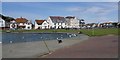
Llandudno Model Boating Lake
by Peter Teal
Model boating lake on the west shore, looking towards Gloddaeth Avenue and the north shore.
|
|
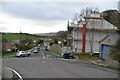
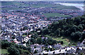
Tyn y Coed Road
by N Chadwick
|
|
Car park on Gloddaeth Avenue, Llandudno
by Ian S
|
|
Tweedledee and Tweedledum
On the Alice in Wonderland Trail.
|
|
Pen Dinas rock cannon on the Great Orme, Llandudno
by Meirion
This rock cannon which has 29 holes in total is located near the Pen-y-Dinas hillfort on the Great Orme in Llandudno. See also: SH7782 : Pen Dinas rock cannon (close-up) on the Great Orme, Llandudno.
|
|
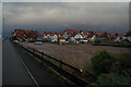
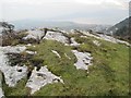
The west end of Llandudno
Taken from the west end of Haulfre gardens. The large green area in the middle distance is the cricket pitch and the Conwy Estuary can just be seen on the right.
|
|
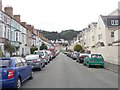
Clifton Road - Lloyd Street |
|
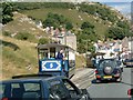
Llandudno - Great Orme Tramway
by Paul Allison
The tramway starts in the town and goes all the way to the summit of the Great Orme. This photo is about half way back down, where the tram re enters the built up areas.
|
|
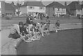
Ready, steady...
About to start a race across the boating pond at the West Shore, Llandudno.
The photograph was probably taken in 1964 or 1965 by the contributors father, Geoffrey William Sutcliffe (1907-2004).
Scanned from an ILFOCOLOR colour negative.
|
|
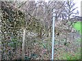
Haulfre Estate Wall
This wall appears to be the old estate wall of the Haulfre Gardens, which was designed to keep people out. Since 1929 visitors have been welcome to this public garden and tea room.
|
|
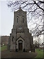
St. George's Church Tower, Church Walks, Llandudno
The church itself is now privately owned, (called Church Walks Business Centre), but the churchyard is still owned by Church in Wales. See SH7782 : Sign in St. George's Churchyard, Llandudno
|
|
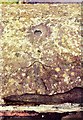
Pivot Bench Mark Llandudno Seilo Chapel
by Cud05
Pivot Bench Mark Llandudno Seilo Chapel NW side, NE face.
|
Explore more images in this square: | View Filtering options | View all 528 images page by page >>> |
|