Grid reference SH7682
near to Gogarth, Conwy, Wales
Coverage
We have
173 images
in grid square SH7682
Contribute
Explore gridsquare SH7682
Surrounding area
Maps
 Map © Crown Copyright")
TIP: Click the map for more Large scale mapping
Tip: Click the map to open the coverage map
A sample of 12 photos from 173
for SH7682
- View this square in the Browser >>>
|
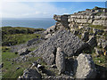
Brachiopod bed
Bedding in the Carboniferous Limestone of this part of the Bishop's Quarry is defined by long-lived surfaces stabilised by colonies of large brachiopod fossils (a type of bivalve). The brachiopods had a thick, curved, lower valve and a... (more)
|
|
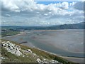
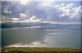
Conwy Bay from the Great Orme
by Paul Allison
Taken from the area marked Maes-Y-Facrell and looking south east. Within this photo can be seen the sewage pipe (bottom right) and breakwater (middle left) along with the mud flats leading towards the River Conwy.
|
|
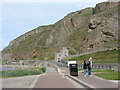
Marine Drive (set of 3 images)
by N Chadwick
|
|
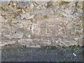
Ordnance Survey Cut Mark
by Adrian Dust
This OS cut mark can be found on the wall SW side of Marine Drive. It marks a point 12.623m above mean sea level.
|
|
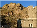
A band of crags above the house |
|
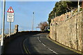
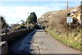
Marine Drive at Gogarth |
|
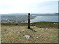
Ordnance Survey block & Waymark post - Maes-y-facrell, Llandudno
by Meirion
An Ordnance survey block style trigpoint can be seen close to the base of the wooden waymark post. See also: SH7682 : Ordnance Survey block - Maes-y-facrell, Llandudno
|

|
Great Orme from West Shore
The side of the Great Orme viewed from West Shore.
|
|
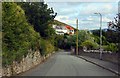
Junction of Llys Helig Drive and the Marine Drive
by Jeff Buck
Llys Helig Drive is a private road leading to very exclusive developments.
|
|
Conwy Bay
Looking south-west towards Snowdonia from the edge of the Great Orme plateau.
|
|
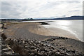
Beach near West Shore
by Bill Boaden
This beach is separated from the main one by the breakwater which projects out into Conwy Bay.
|
|
The former western toll house on Marine Drive
by Eric Jones
With the introduction of a one way traffic system (except for limited two-way access to nearby dwellings) the western toll house became redundant.
|
Explore more images in this square: | View Filtering options | View all 173 images page by page >>> |
|