Grid reference SH3545
near to Llithfaen, Gwynedd, Wales
Coverage
We have
74 images
in grid square SH3545
Contribute
Explore gridsquare SH3545
Surrounding area
Maps
 Map © Crown Copyright")
TIP: Click the map for more Large scale mapping
Tip: Click the map to open the coverage map
A sample of 12 photos from 74
for SH3545
- View this square in the Browser >>>
|
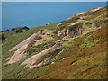
Quarry Workings Above Nant Gwrtheyrn |
|
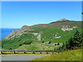
View to Garn Fôr (centre) from the road to Nant Gwrtheyrn
by Rod Grealish
Garn Fôr (Big Cairn in English) at 444 metres is the lowest of the three summits of Yr Eifl. It is 2 kilometres north of the camera position. There is a microwave radio relay station on its east side, which is just visible in the image. On... (more)
|
|
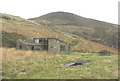
Disused Quarry Building
by Karen Foxall
|
|
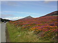
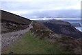
Tuag at Fwlch yr Eifl / Towards Bwlch yr Eifl
Cerddwyr yn dilyn Llwybr Arfordir Cymru tuag at Fwlch yr Eifl. Y fan yn y pellter yw Graig For.
Walkers following the Wales Coastal Path towards Bwlch yr Eifl (trans. pass of the fork). The peak in the distance is Graig For (trans. sea crag).
|
|
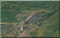
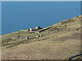
Quarry building at the base of the Trwyn y Gorlech quarry
by Eric Jones
The base of the zig-zag track can be seen beyond the building. The track on the left led to the inclined plane and crusher.
SH3545 : Quarry building serving the lower gallery of the Trwyn y Gorlech quarry
|
|
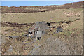
Derelict quarry building in Nant Gwrtheyrn
by Eirian Evans
|
|
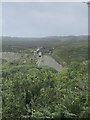
Nant Gwrtheyrn
by Richard Webb
Farmland upstream of the old quarry village. The incredibly steep Craig Ddu dodging road in can be seen in the background.
|
|
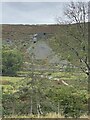
Disused quarry and spoil heap
by Alan Hughes
|
|
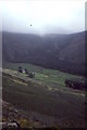
View from a bench by the Porth-y-Nant road
by Eirian Evans
Looking north-east, the Nant Gwrtheyrn Quarry on Trwyn y Gorlech, half way up the hill and the larger Eifl Quarry at the summit. The latter on Mynydd Gwaith was approached from the village of Trefor.
|
|
Abandoned buildings at the top of the Trwyn y Gorlech section of the Nant Quarry
by Eric Jones
|
|
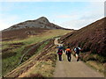
Lleyn Coastal Path 020
by Row17
Evening falls over the Lleyn Peninsula.
|
|
Granite crusher and hopper, Cae'r Nant Quarry
by Kate Jewell
Telephoto shot, taken from the car park at the Nant Gwrtheyrn Welsh Language Centre, of the derelict granite crusher and the hopper used for loading the wagons at the top of the incline leading to the chippings storage bins and loading pier... (more)
|
Explore more images in this square: | View Filtering options | View all 74 images page by page >>> |
|