Grid reference NY7287
near to Falstone, Northumberland, England
Coverage
We have
48 images
in grid square NY7287
Contribute
Explore gridsquare NY7287
Surrounding area
Maps
 Map © Crown Copyright")
TIP: Click the map for more Large scale mapping
Tip: Click the map to open the coverage map
Sample images
Breakdown list
images taken from NY7287 [2]
A sample of 12 photos from 48
for NY7287
- View this square in the Browser >>>
|
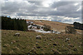
Falstone Burn
View looking across Falstone Burn from Hawkhope Hill.
|
|
Near Falstone
by T Eyre
Beside the road SE of Falstone.
|
|
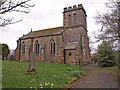
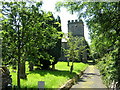
St Peters Church, Falstone
by wfmillar
|

|
Cemetery at Falstone |

|
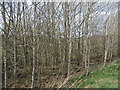
Disused railway line near Falstone Station
by Les Hull
|
|
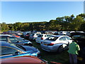
Before the 2013 Kielder Marathon
by John H Darch
The event car park in Falstone.
|
|
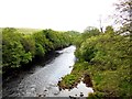
The North Tyne River
This is the view downstream from Falstone Bridge.
|

|
Ordnance Survey rivet
by Michael Rye
The rivet indicates an elevation of 138.52m a.s.l. and was placed by the Ordnance Survey.
|

|
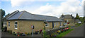
Children's play area at Falstone
by Oliver Dixon
|
|
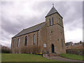
St Peter's Church Falstone |
|
Falstone United Reformed Church
by wfmillar
|
|
Falstone Railway Station
by Les Hull
An extension has been added to the original building and part of this is self-catering accommodation.
|
Explore more images in this square: | View Filtering options | View all 48 images page by page >>> |
|