Grid reference NY7187
near to Falstone, Northumberland, England
Coverage
We have
16 images
in grid square NY7187
Contribute
Explore gridsquare NY7187
Surrounding area
Maps
 Map © Crown Copyright")
TIP: Click the map for more Large scale mapping
Tip: Click the map to open the coverage map
Sample images
Breakdown list
images taken from NY7187 [3]
A sample of 12 photos from 16
for NY7187
- View this square in the Browser >>>
|
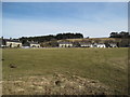
Houses between Falstone and Kielder Dam
by Les Hull
These houses are typical of the type of house that were built for forestry workers here and elsewhere in the Kielder Area.
|
|
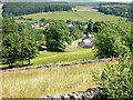
Yarrow Near Kielder Water
Yarrow is in the foreground while Falstone is in the background
|
|
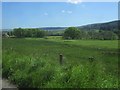
Countryside on the road to Hawkhope
Looking back in the direction of Falstone and the North Tyne.
|

|
Kielder Service Road
Service road running from the entrance to the Kielder Dam up to the main road at Shilling Pot.
|

|
Kielder Dam
by Ian Porter
The Kielder earth dam. The outflow, the North Tyne, is not visible in this photograph although the overflow spillway is in the foreground. The length of the dam is very close to 1000 metres.
|
|
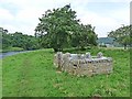
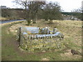
"The Stell" at Falstone
by Oliver Dixon
For details, see NY7187 : Stell, Falstone.
|
|
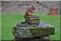
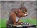
Red squirrel in garden at our B&B |
|
|
Hawkhope
View of pasture alongside the North Tyne at Hawkhope. Kielder Dam is visible in the background.
|
|
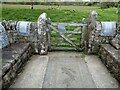
Stell, Falstone
by Oliver Dixon
"Stell" is derived from the old Norse word, meaning circular stone walled shelter for sheep, and is a Northumbrian word for sheepfold.
This sculpture by Colin Welbourn installed in 2008 commemorates in stone the very warm... (more)
|
|
Red squirrel in garden at our B&B
I have zoomed in to the squirrel.
|

|
Stell, Falstone
by Oliver Dixon
"Stell" is derived from the old Norse word, meaning circular stone walled shelter for sheep, and is a Northumbrian word for sheepfold.
This sculpture by Colin Welbourn installed in 2008 commemorates in stone the very warm... (more)
|
|
The Stell, Falstone
For more information see: Link
|
Explore more images in this square: | View Filtering options | View all 16 images page by page >>> |
|