Grid reference NY5361
near to Brampton, Cumbria, England
Coverage
We have
177 images
in grid square NY5361
Contribute
Explore gridsquare NY5361
Surrounding area
Maps
 Map © Crown Copyright")
TIP: Click the map for more Large scale mapping
Tip: Click the map to open the coverage map
A sample of 12 photos from 177
for NY5361
- View this square in the Browser >>>

|
Brampton Ridge
The cloud ebbed and flowed and allowed me to capture this wonderful scene along the edge. Moments later the view was lost in thick fog!
|
|
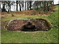
The Mote Well
The Mote Well, located on the hill just below a statue to the 7th Earl of Carlisle. This structure appears to be either a drinking fountain, or spring water trough.
|
|
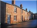
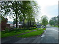
Row of cottages, Craw Hall |

|
North end of footpath from Brampton Station to Station Road, Brampton
The footpath ends here at the dismantled railway bridge NY5361 : View along Station Road where it passes the remains of railway bridge which formerly carried the branch line into Brampton Town Station
|
|
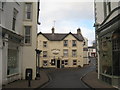
The White Lion, Brampton
Seen down High Cross Street.
|
|
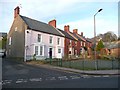
Oval House and Terrace, Brampton
Oval House has a 'bed and breakfast' sign. It looks as if all four houses were built about the same time. Although Oval House has a verge at each end of its roof, the chimney for the first of the three smaller houses rises from... (more)
|
|
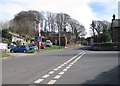
Entering Brampton village from the East
by Ann Hodgson
|
|
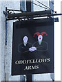
Sign for The Oddfellows Arms, Main Street, CA8
by Mike Quinn
|
|
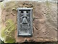
Benchmark, Brampton, former Sands Hotel
Detail of the Ordnance Survey flush bracket benchmark number G3837 on the north east corner, north face of the former Sands Hotel, Brampton. The benchmark marks a height of 81.5609m above mean sea level (Ordnance Datum Newlyn) last levelled... (more)
|
|
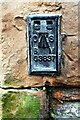
Benchmarks on house at junction of A6071 and Station Road
Ordnance Survey flush bracket (identifier G3837) benchmark installed over an earlier cut mark. The flush bracket was installed in 1955 and verified in 1972, levelled at 81.561m above Newlyn Datum. The cut mark was cut in 1844 and levelled... (more)
|
|
Brampton Town railway station (site), Cumbria
Opened in 1836 by the Newcastle & Carlisle Railway along the course of an earlier waggonway, this was the terminus of the short branch line to Brampton Junction. It mainly carried goods and miners but was open for passengers 1881-90,... (more)
|
|
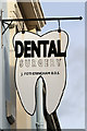
A dentist's sign in Brampton
This unusual sign is outside this dental practice in the town centre NY5361 : A dental surgery in Brampton.
|
Explore more images in this square: | View Filtering options | View all 177 images page by page >>> |
|