Grid reference NY4506
near to Kentmere, Cumbria, England
Coverage
We have
18 images
in grid square NY4506
Contribute
Explore gridsquare NY4506
Surrounding area
Maps
 Map © Crown Copyright")
TIP: Click the map for more Large scale mapping
Tip: Click the map to open the coverage map
Sample images
Breakdown list
images taken from NY4506 [2]
A sample of 12 photos from 18
for NY4506
- View this square in the Browser >>>
|
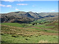
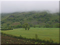
The upper Kentmere valley
From the northern slopes of Green Quarter Fell, showing the western part and the head of the Kentmere Horseshoe.
|
|
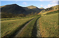
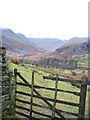
Farm track to Tongue House
Tongue house lies under Tongue Scar showing through the gate
|

|
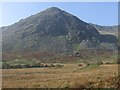
Hungry sheep in upper Kentmere
by Karl and Ali
Tucking into silage below the snowy bulk of Rainsborrow Crag.
|
|
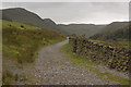
Track to Kentmere Reservoir |
|
Settlement
This image taken from the footpath at ny4510306947 looks across the pasture land towards Rainsborrow Crag. Two green mounds can be seen in the foreground, one to the centre and the nearer one on the right, these are marked as... (more)
|
|
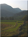
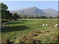
Pasture South of Kentmere
Pasture land South of Kentmere
|
|
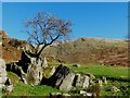
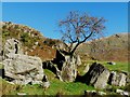
Hawthorn tree growing on rock |
|
The footpath to Tongue House and upper Kentmere
by Karl and Ali
Tongue House is the rather grand name for the barn which sits below Tongue Scar, the rocky spur which divides upper Kentmere from Ullstone Gill. Dominating the upper dale are the conical peaks of Ill Bell and Froswick.
|
|
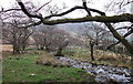
Stream above Hartrigg
by michael ely
This stream is a tributary of the River Kent.
|
|
Trees in field
by Nigel Brown
|
|
Hawthorn tree living in a rock |
|
Pasture land Valley floor
This picture taken looking W from the footpath at ny4586206397 shows Pasture land along the course of the River Kent as it flows along the valley bottom.
|
Explore more images in this square: | View Filtering options | View all 18 images page by page >>> |
|