Grid reference NN5732
near to Killin, Stirling, Scotland
Coverage
We have
246 images
in grid square NN5732
Contribute
Explore gridsquare NN5732
Surrounding area
Maps
 Map © Crown Copyright")
TIP: Click the map for more Large scale mapping
Tip: Click the map to open the coverage map
A sample of 12 photos from 246
for NN5732
- View this square in the Browser >>>
|
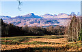
Rough grazing with rushes near Killin
A roughly vegetated enclosure on the east side of the River Tay and also the route of an old railway that once served Killin.
The mountains in the distance are those of the Meall nan Tarmachan group.
|
|
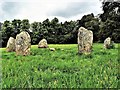
Kinnell Stone Circle - Killin
There are six stones in the ling and they are arranged on the circumference of a flattened circle measuring 9.5m by 8.5m in diameter. Unlike some other circles, the stones are not graded in height but the two tallest stones (up to 2m high)... (more)
|
|
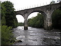
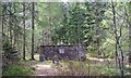
Old Railway Bridge over the River Dochart
by Iain Lees
|
|
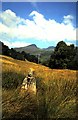
Fingal's Grave
by ronnie leask
Legends of Fingal abound in this area & indeed the name Killin is said to derive from Cill Fhinn, the 'Cell of Fingal'. This stone behind the village is said to mark his grave. He was killed by his adversary Taileachd who cut... (more)
|
|
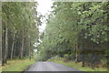
Rob Roy Way and National Cycleroute 7, Auchmore Wood
by N Chadwick
|
|
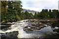
Falls of Dochart
by John Gibson
View of the River Dochart, taken from just below the road through Killin, looking downstream across the Falls of Dochart towards the bridge of the same name.
|
|
Falls of Dochart
by Les Hull
|
|
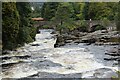
Old Mill and Falls of Dochart, Killin
by Jim Barton
Originally a meal mill, the building now houses the tourist information centre.
|
|
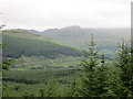
Meall nan Tarmachan from the Rob Roy Way
by Peter S
A glimpse of this Munro, partly covered in cloud, between stretches of forest on the Rob Roy Way. One of just a few views on a stretch that is largely dominated by trees on either side of the track.
|
|
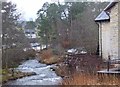
Clan MacNab burial ground
by Mike Green
The ground is located on an island, only accessible via a gate from the bridge at Killin, for which the key may be obtained by following instructions at the sign on the entrance gate.
|
|
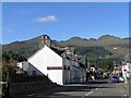
Main Street, Killin, Scotland
by Ann Causer
|
|
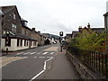
A827 in Killin, near the primary school
by Dawgy
The A827 in Killin, taken near the primary school.
|
Explore more images in this square: | View Filtering options | View all 246 images page by page >>> |
|