Grid reference NH1394
near to Ullapool, Highland, Scotland
Coverage
We have
101 images
in grid square NH1394
Contribute
Explore gridsquare NH1394
Surrounding area
Maps
 Map © Crown Copyright")
TIP: Click the map for more Large scale mapping
Tip: Click the map to open the coverage map
A sample of 12 photos from 101
for NH1394
- View this square in the Browser >>>

|
School, Ullapool
by Peter Bond
|
|
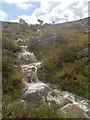
Allt Leacach
by Mick Garratt
|
|
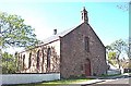
Ullapool Church of Scotland |
|
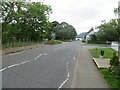
Mill Street (A835), Ullapool
by Peter Wood
Looking south-eastward.
|
|
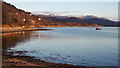
East end of the shore at Ullapool |
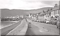
|
Shore Street, Ullapool
The Ferry Boat Inn is on the right and the SYHA youth hostel is a bit further down the street.
|
|
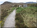
Path to Ullapool Hill |
|
The side of Meall Mor - Ullapool Hill
by Julian Paren
Marked as woodland on OS Mapping this is very open country with only sparse tree cover. Excellent footpaths cross the area including one up Meall Mor, which a person in blue is following in the photo.
|
|
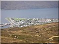
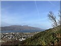
Ullapool
by Graham Scott
Ullapool and Loch Broom from the viewpoint above the town.
|
|
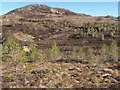
On Ullapool Hill |
|
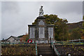
The War Memorial, Ullapool
by Ian S
|
|
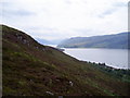
Braes of Ullapool, Wester Ross, Scotland
by Graham Hogg
Looking towards Loch Broom from the hills behind Ullapool
|
Explore more images in this square: | View Filtering options | View all 101 images page by page >>> |
|