Grid reference NF1099
near to Oisebhal [hill or Mountain], Na h-Eileanan an Iar, Great Britain
Coverage
We have
205 images
in grid square NF1099
Contribute
Explore gridsquare NF1099
Surrounding area
Maps
 Map © Crown Copyright")
TIP: Click the map for more Large scale mapping
Tip: Click the map to open the coverage map
Sample images
Breakdown list
images taken from NF1099 [17]
mentioning NF1099 [1]
taken pre 2000 [26]
A sample of 12 photos from 205
for NF1099
- View this square in the Browser >>>
|
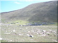
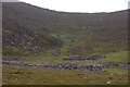
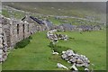
Sheep enclosures at An Lag Bho'n Tuath |
|
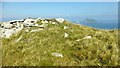
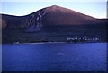
Oisebhal, Hirta
by Rude Health
Bagged on a circuit of six Hirta TUMPs on a sunny afternoon.
Name: Oisebhal [Oiseval]
Hill number: 4985
Height: 293m / 961ft
Parent (Ma/M): 1636 Conachair
Section: 25: St Kilda
County/UA: Na h-Eileanan Siar [Western Isles] (UA)... (more)
|
|
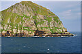
Oiseval (Oisebhal)
by David Dixon
Oiseval (Gaelic: Oisebhal) is a significant summit on Hirta, the principal island of the St Kilda archipelago. It rises steeply from the sea to a height of 961 feet.
|
|
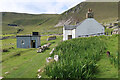
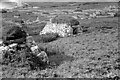
Factor's House, St Kilda
The factor was the representative of the Laird and visited to collect rent from the islanders. Since the evacuation it has been used by the military and now by the National Trust for Scotland and visiting researchers.
|
|
An Lag and the ascent to the Gap, St Kilda
A line of cleits marks the ascent to the Gap.
|
|
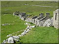
Cleits above the Main Street, Hirta, St Kilda
by Julian Paren
Hirta is peppered by cleits which were used to air-dry their winter stores. The row of houses built in 1830 is also visible.
|
|
St Kilda - Hirta - Village Street - roofless houses looking west
by Rob Farrow
All the most westward of the houses along the street in the abandoned village of St Kilda on the island of Hirta no longer have their roofs.
|

|
Shoreline of Village Bay
by John Allan
The "St Kilda International Sea and Airport Lounge" was named by someone with a sense of humour!
|
|
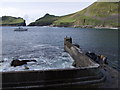
The Jetty on St Kilda
by Mick Crawley
The only safe landing on the island of Hirta, the jetty saw the evacuation of the last islanders in August 1930. Now used only for visitors, since the residents are supplied by twice-weekly helicopters from Benbecula and occasional landing... (more)
|
|
Hirta, St Kilda
by DJB
Former village.
|
|
Hirta, St Kilda
Early morning, the village still in shadow - a view from the tank landing craft on which I travelled to St Kilda
|
|
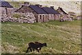
Restored houses, The Street, Village Bay
Houses 3 and 2, both new houses built in 1861. Restored by the National Trust for Scotland. The ruins of the original black houses, replaced by the new buildings stand beside them.
Two Soay lambs graze in the foreground.
|
Explore more images in this square: | View Filtering options | View all 205 images page by page >>> |
|